Geodata Germany - X 64-bit Download
Popular x64 Tags
- dbase x64 download
- data x64 download
- excel x64 download
- odbc x64 download
- mysql x64 download
- unix x64 download
- sql server x64 download
- gui x64 download
- dbf x64 download
- export x64 download
- database x64 download
- csv x64 download
- import x64 download
- development x64 download
- oracle x64 download
- sybase x64 download
- mdb x64 download
- tool x64 download
- access x64 download
- server x64 download
- ems x64 download
- sql x64 download
- software x64 download
- query x64 download
- txt x64 download
- dbms x64 download
- search x64 download
- table x64 download
- rdbms x64 download
- sqlmanager x64 download
Geodata Germany 25.02
Sponsored links:
license: Data Only ($175.00)
downloads: 589
size: 3.16 MB
updated: 2016-02-22
tags: geo, data, geodata, coordinate, coordinates, periphery, proximity, search, nature, area, landscape
Add to Basket
Killet GeoSoftware Ing.-GbR

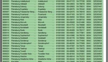
The database tables contains geodata of the Federal Republic of Germany with geo referenced towns, municipalities, town quarters and other administrative units, postal codes, telephone preselections, nature areas, landscapes, climatic zones and official topographical cartographies. The data contain coordinates for navigation and geo-coding, proximity searches and distance computations and are prepered for the spatial mapping of environmental information. Quite often it is necessary to reference an address field e.g. like town or municipality name, postal code or telephone preselection, to corresponding geographical data and coordinates - a Geo Reference. The geo reference can be used e.g. to direct a customer to the closest store locations of a retail store chain by doing a proximity search. Another possibility it to determine distances between the different objects of the database tables with the included geo references. With the elevation data from a Digital Elevation Model the ground level height of each place can be determined. Often the knowledge is necessary about affiliations and relationships between data derived from different hierarchies. So it can be determined to which federal state, governmental area or governmental county a town, a postal code or a telephone preselection is associated. It is possible to assign a variety of natural and scenic information to each town or municipality. The snow and wind load zones and solar irradiation are available as local climatic data. In conjunction with the ground level heights they can be used to calculate static loads for the planning of building constuctions and to calculate solar installations. Databases: 11.500 Towns and Municipalities, 108.000 Town Quarters, 31.000 Postal Codes, 19.500 Telephone Preselections, all with geo references, 400 Administrative Countys, Administrative Districts, Federal States of Germany, Landscapes, Nature Area Classification, Snow and Wind Load Zones, Solardata, Cartographies.
OS: Win2000, Windows XP, Windows 7 x32, Windows 7 x64, Windows 8, Windows 10, WinServer, WinOther, Windows Vista, Windows Vista x64
Requirements: All systems, only data
Add Your Review or 64-bit Compatibility Report
Top Databases & Tools 64-bit downloads


Rons Data Stream 2024.04.02.0829
Rons Data Stream is a tool for cleaning/converting/processing large data files.
Freeware
tags: Data Processing, Data Cleaner, Free Program, CSV File, Automatic Data Cleaning, Batch CSV Processor, Batch Data Processing, Batch Data Cleaning, CSV Editor, Rons Data Edit, CSV Converter, CSV Files, Tab, Editor, Conversion, Convert, Converter, Analysis, Delimited File, SQL, SQLite, Parquet, JSON, XML, HTML

Google Maps Contact Extractor 2.5.3.57
Google maps Contact Extractor software - Google maps scraper
Shareware | $119.95

Database Tour Pro 11.1.5.163

Universal database tool with built-in report builder
Shareware | $97.00


Structured Storage Viewer 4.1.2
This tool allows completely manage any MS OLE Structured Storage based file
Freeware
GeneralKB 2.8
Create and maintain knowledge base. Organize your documents, notes, web pages.
Shareware | $49.00


FoxPro Sybase ASE Import, Export & Convert Software 7.0
Transfer tables to and from FoxPro and Sybase ASE (Adaptive Server Enterprise).
Shareware | $29.99
Members area
Top 64-bit Downloads
-
Microsoft Office 2016
x64 2403 B17425.201
x64 trialware download -
Microsoft Office 2010
x64 14.0.6023.1000
x64 trialware download -
Microsoft Office 2013
x64 15.0.4420.1017
x64 trialware download -
PSPP x64 1.6.2
x64 open source download -
Microsoft OneNote 2013
x64 15.0.4641.1001
x64 freeware download -
MiKTeX 64bit 24.1
x64 open source download -
GS-Base x64 20.3
x64 trialware download -
Rons Data Stream 2024.04.02.0829
x64 freeware download -
mbFXWords 2.80
x64 freeware download -
LibreOffice x64 24.2.2
x64 open source download
Top Downloads
-
Microsoft Office 2016
x64 2403 B17425.201
trialware download -
Microsoft Office 2007
trialware download -
OpenOffice.org 4.1.15
open source download -
Microsoft Office 2003
commercial download -
Microsoft Office 2010
x64 14.0.6023.1000
trialware download -
Quite Imposing Plus 5.3n
demo download -
Talend Open Studio 8.0.1
open source download -
Grammarly 6.8.263
freeware download -
Adobe Reader 9 9.5.1
freeware download -
Microsoft Office 2013
x64 15.0.4420.1017
trialware download -
TotalReminder 8.2
trialware download -
PSPP x64 1.6.2
open source download -
JSignPdf 2.2.0
freeware download -
SmarThru Office 2.07.10
freeware download -
Adobe Acrobat XI Pro 11.0.10
trialware download