Geodata International - X 64-bit Download
Popular x64 Tags
- dbase x64 download
- data x64 download
- excel x64 download
- odbc x64 download
- mysql x64 download
- unix x64 download
- sql server x64 download
- gui x64 download
- dbf x64 download
- export x64 download
- database x64 download
- csv x64 download
- import x64 download
- development x64 download
- oracle x64 download
- sybase x64 download
- mdb x64 download
- tool x64 download
- access x64 download
- server x64 download
- ems x64 download
- sql x64 download
- software x64 download
- query x64 download
- txt x64 download
- dbms x64 download
- search x64 download
- table x64 download
- rdbms x64 download
- sqlmanager x64 download
Geodata International 13.03
Sponsored links:
license: Data Only ($165.00)
downloads: 347
size: 2.28 MB
updated: 2021-06-11
tags: geo, data, geodata, point, pointdata, spatial, reference, coding, coordinates, places, local, localities, town, quarters, postal, zip, code, periphery, search, distance, calculation, elevation, list, listing, municipality, database, longitude, latitude, geographic, utm, wgs84
Add to Basket
Killet GeoSoftware Ing.-GbR

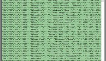
Geodata International - World-wide database of countries with georeferenced towns, municipalities, postal codes and administrative units with WGS84 and UTM coordinates and elevations for geocoding, proximity search, navigation, distance calculation. Often is it necessarily, for an address characteristic, e.g. the place name or the postal code, to establish a local relationship - a georeference. The georeference can be used e.g. to show a customer the nearest chain store by doing a proximity search. On the basis of the georeferences business zones, statistics or general maps can be made. Towns, municipalities and postal codes can be assigned to the superordinated administrative units. Distances between places or postal areas can be determined with the coordinates contained in the database tables. For that the georeferences are available in all country database tables as UTM coordinates on the natural and an uniformly meridian strip and as geographical coordinates in degree and deg/min/sec notation. With the elevation data from a Digital Elevation Model the ground level height of each place can be determined. The database tables are present in the file format CSV (Comma Separated Values). The character set used is UTF8. This format is used often and in most cases you can import data directly into your own data system. The freeware program CONVERT, downloadable from the KilletSoft site, converts the available database tables to other data formats and character sets with the necessary sortings and selections. With the program, for example, CSV data can be converted to the SDF format (Simple Document Format) or to the dBase format. For the use of the data on different platforms it is possible to select between the character sets ASCII, ANSI, UTF8 and UniCode. Thus the import of the data in any database management system or file system will be possible.
OS: Win2000, Windows XP, Windows 7 x32, Windows 7 x64, Windows 8, Windows 10, WinServer, WinOther, Windows Vista, Windows Vista x64
Requirements: All systems
Add Your Review or 64-bit Compatibility Report
Top Databases & Tools 64-bit downloads


Rons Data Stream 2024.04.02.0829
Rons Data Stream is a tool for cleaning/converting/processing large data files.
Freeware
tags: Data Processing, Data Cleaner, Free Program, CSV File, Automatic Data Cleaning, Batch CSV Processor, Batch Data Processing, Batch Data Cleaning, CSV Editor, Rons Data Edit, CSV Converter, CSV Files, Tab, Editor, Conversion, Convert, Converter, Analysis, Delimited File, SQL, SQLite, Parquet, JSON, XML, HTML

Google Maps Contact Extractor 2.5.3.57
Google maps Contact Extractor software - Google maps scraper
Shareware | $119.95

Database Tour Pro 11.1.4.346
Universal database tool with built-in report builder
Shareware | $97.00


Exportizer 9.2.8.201
Free database export tool
Freeware
tags: Database, export, DBF, CSV, XLS, RTF, XML, HTML, ADO, BDE, database tool, db tool, database utility, db utility, database software, command line, clipboard, utility, text export, files, exporting

Structured Storage Viewer 4.1.2
This tool allows completely manage any MS OLE Structured Storage based file
Freeware

MDB Viewer Plus 2.63
Freeware viewer plus and editor for Microsoft Access MDB database files
Freeware

MS Access to MySQL Loader 3.5
MS Access to MySQL Loader is a tool to convert data from Access to MySQL
Shareware | $99.00

Members area
Top 64-bit Downloads
-
Microsoft Office 2016
x64 2403 B17425.201
x64 trialware download -
Microsoft Office 2010
x64 14.0.6023.1000
x64 trialware download -
Microsoft Office 2013
x64 15.0.4420.1017
x64 trialware download -
PSPP x64 1.6.2
x64 open source download -
Microsoft OneNote 2013
x64 15.0.4641.1001
x64 freeware download -
MiKTeX 64bit 24.1
x64 open source download -
GS-Base x64 20.3
x64 trialware download -
Rons Data Stream 2024.04.02.0829
x64 freeware download -
LibreOffice x64 24.2.2
x64 open source download -
Microsoft Deployment
Toolkit x64 6.3.8456.1000
x64 freeware download
Top Downloads
-
Microsoft Office 2016
x64 2403 B17425.201
trialware download -
OpenOffice.org 4.1.15
open source download -
Microsoft Office 2010
x64 14.0.6023.1000
trialware download -
Microsoft Office 2007
trialware download -
Microsoft Office 2003
commercial download -
Quite Imposing Plus 5.3n
demo download -
Talend Open Studio 8.0.1
open source download -
Grammarly 6.8.263
freeware download -
Adobe Reader 9 9.5.1
freeware download -
Microsoft Office 2013
x64 15.0.4420.1017
trialware download -
TotalReminder 8.2
trialware download -
SmarThru Office 2.07.10
freeware download -
Adobe Acrobat XI Pro 11.0.10
trialware download -
Easy Tables 2.3
freeware download -
PSPP x64 1.6.2
open source download