Geodata Germany - X 64-bit Download
Popular x64 Tags
- data x64 download
- excel x64 download
- dbase x64 download
- odbc x64 download
- unix x64 download
- mysql x64 download
- sql server x64 download
- gui x64 download
- dbf x64 download
- export x64 download
- oracle x64 download
- development x64 download
- sybase x64 download
- database x64 download
- mdb x64 download
- import x64 download
- csv x64 download
- access x64 download
- tool x64 download
- server x64 download
- sql x64 download
- software x64 download
- ems x64 download
- txt x64 download
- table x64 download
- dbms x64 download
- rdbms x64 download
- query x64 download
- search x64 download
- sqlmanager x64 download
Geodata Germany 29.05
Sponsored links:
license: Data Only ($175.00)
downloads: 638
size: 3.57 MB
updated: 2025-02-18
tags: geodata, cities, towns, municipalities, postal codes, area codes, coordinates, georeferences, perimeter search, natural area, landscape, snow load, wind load, solar radiation, distance calculation, administrative units
Add to Basket
Killet GeoSoftware Ing.-GbR

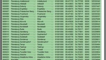
The database tables contains geodata of the Federal Republic of Germany with geo referenced towns, municipalities, town quarters and other administrative units, postal codes, telephone preselections, nature areas, landscapes, climatic zones and official topographical cartographies. The data contain coordinates for navigation and geo-coding, proximity searches and distance computations and are prepered for the spatial mapping of environmental information. Quite often it is necessary to reference an address field e.g. like town or municipality name, postal code or telephone preselection, to corresponding geographical data and coordinates - a Geo Reference. The geo reference can be used e.g. to direct a customer to the closest store locations of a retail store chain by doing a proximity search. Another possibility it to determine distances between the different objects of the database tables with the included geo references. With the elevation data from a Digital Elevation Model the ground level height of each place can be determined. Often the knowledge is necessary about affiliations and relationships between data derived from different hierarchies. So it can be determined to which federal state, governmental area or governmental county a town, a postal code or a telephone preselection is associated. It is possible to assign a variety of natural and scenic information to each town or municipality. The snow and wind load zones and solar irradiation are available as local climatic data. In conjunction with the ground level heights they can be used to calculate static loads for the planning of building constuctions and to calculate solar installations. Databases: 11.500 Towns and Municipalities, 108.000 Town Quarters, 31.000 Postal Codes, 19.500 Telephone Preselections, all with geo references, 400 Administrative Countys, Administrative Districts, Federal States of Germany, Landscapes, Nature Area Classification, Snow and Wind Load Zones, Solardata, Cartographies.
OS: Win2000, Windows XP, Windows 7 x32, Windows 7 x64, Windows 8, Windows 10, WinServer, WinOther, Windows 2000, Windows 2003, Windows Server 2000, Windows Server 2003, Windows Server 2008, Windows Server 2008r2, Windows Server 2012, Windows Tablet PC Edition 2005, Windows Media Center Editi
Requirements: All systems, only data
Add Your Review or 64-bit Compatibility Report
Top Databases & Tools 64-bit downloads

PostgreSQL Sybase ASE Import, Export & Convert Software 7.0
Transfer tables to and from PostgreSQL and Sybase ASE.
Shareware | $29.99


DBF Recovery 4.68

Effortlessly restore corrupted DBF files with powerful recovery tools.
Demo | $39.95

Small Library Organizer Pro 3.2b
Easily catalog library collections, manage member and circulation data.
Shareware | $245.00


DataNumen DBF Repair 4.0
DataNumen DBF Repair is a powerful tool to repair corrupt DBF files.
Shareware | $149.95
tags: dbf repair, repair dbf, dbf recovery, recover dbf, fix dbf, dbf fix, corrupt dbf, corrupted dbf, damaged dbf, dbf corruption, dbf, repair, file, corrupt, fix, database, dbase, foxpro, foxbase, corrupted, files, damaged, recovery, recover, salvage, restore, oversized, 2gb, split

Visual Importer ETL Enterprise 32 Bit 9.2.6.8
Automate loading data into ANY Database from ANY Database or file
Shareware | $330.00
tags: ETL, Powerful ETL tool, Oracle, MS Sql server, BCP, sql loader, ODBC, ETL, Datawarehouse, business automation

Visual Importer ETL Professional 32 Bit 9.2.6.8
Automate loading data into Oracle, SQL Server, ODBC from flat files or ODBC
Shareware | $220.00

Database Browser 5.3.2.13
This Easy to use tool allows the user to connect to any database and browse it.
Freeware
Members area
Top 64-bit Downloads
-
Office Tab x64 8.50
x64 shareware download -
ABBYY FineReader
Professional 16.0.13
x64 trialware download -
Microsoft Office 2010
x64 14.0.6023.1000
x64 trialware download -
clrmamepro x64 4.048d
x64 freeware download -
Zed Axis 64bit 10.0
x64 trialware download -
PSPP x64 1.6.2
x64 open source download -
Foxit Reader 2023.3
x64 freeware download -
Hl7Spy 24.1.227
x64 trialware download -
Talygen x64 7.0
x64 trialware download -
Microsoft Office 2010
Service Pack x64 SP2
x64 freeware download
Top Downloads
-
Zed Axis 64bit 10.0
trialware download -
CHM to Flash Brochure 2.0
shareware download -
SlidePDF to Flash Book 1.0
freeware download -
ImageWinSoft Free Image
to PDF 1.5
freeware download -
PostgreSQL Sybase ASE
Import, Export &
Convert Software 7.0
shareware download -
sitewebdesk 7.8
demo download -
Label Spirit PrintOnly 7.0.17
shareware download -
ISMN barcode generator 2 2.91
shareware download -
Adaptive Modeler 1.6.0
shareware download -
Gekko 1.6
freeware download -
Office Tab x64 8.50
shareware download -
MS Word Resume Template
Software 7.0
shareware download -
ABBYY FineReader
Professional 16.0.13
trialware download -
Quite Imposing Plus 6.0d
demo download -
Hyper Publish PRO 2016.34
shareware download