Global Mapper x64 - X 64-bit Download
Popular x64 Tags
- chinese x64 download
- ebook x64 download
- music x64 download
- study x64 download
- guitar x64 download
- software x64 download
- fuel consumption x64 download
- free x64 download
- learn x64 download
- learn guitar x64 download
- quiz x64 download
- manager x64 download
- education x64 download
- metronome x64 download
- math x64 download
- vehicle x64 download
- tuner x64 download
- tracker x64 download
- online guitar lessons x64 download
- beginner guitar lessons x64 download
- training x64 download
- german translator x64 download
- simulator x64 download
- test x64 download
- tournament x64 download
- medical office notes x64 download
- medical template x64 download
- homeowners insurance x64 download
- zqcert x64 download
- baby bedding x64 download
Global Mapper x64 25.1
Sponsored links:
license: Demo ($499.00)
downloads: 1142
size: 280.00 MB
updated: 2024-02-15
tags: x64 geographical data, x64 data production, x64 GIS data, x64 geographic, x64 geographical, x64 gheography
Add to Basket
Blue Marble Geographics

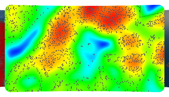
Global Mapper is more than just a utility; it has built in functionality for distance and area calculations, raster blending, feathering, spectral analysis and contrast adjustment, elevation querying, line of sight calculations, cut-and-fill volume calculations, as well as advanced capabilities like image rectification, contour generation from surface data, view shed analysis (including Fresnel) from surface data, watershed delineation, terrain layer comparison (including differencing), and triangulation and gridding of 3D point data. Repetitive tasks can be accomplished using the built in scripting language or comprehensive batch conversion functionality.
Have you ever received a dataset that does not match the projection of your current project? Simply load the dataset into Global Mapper, change the projection, and save the file to match your coordinate system. If the dataset is larger than the area you are interested in, export the data using the crop feature and change the projection and format of the data at the same time.
Your data files can be loaded as layers, for example a Digital Elevation Model (DEM) can be loaded with a scanned topographical map to create a 3D view of the map. A digital aerial image can be draped on the surface together with vector contour mapping to create a stunning and informative graphic. The results can be printed, or the workspace can be exported to a high resolution raster image for use in a presentation or report.
FEATURES:
Provides direct access to DigitalGlobe high resolution color imagery and OpenStreetMap.org detailed street maps for the entire world from within the application!
Provides direct access to the complete TerraServer-USA satellite imagery and topographic map archive for the entire US free-of-charge within the application!
Provides easy, direct access to WMS data sources, including built-in access to the complete 30-m NED database, the 3-arc second world SRTM database, and color global Landsat imagery free-of-charge within the application!
Supports true 3D viewing of loaded elevation and 3D vector data including draping of any loaded imagery and vector data over the 3D surface.
Crop, reproject, and merge/mosaic any combination of raster data and elevation data, including DRGs. You can also crop data to an area feature. Data will automatically mosaic into the correct location relative to each other using positioning information associated with the data.
GeoPDF® SUPPORT! You can import GeoPDF® files and export any collection of loaded data to new Geo-enabled PDF files, making your data accessible to any user without requiring them to have any mapping knowledge.
DIGITIZING SUPPORT! You can digitize new vector (area, line, and point) features by drawing them with the mouse. You can also edit existing vector features. Newly created and editing features can be saved to any of the supported export formats. In addition, shapes like rectangles, circles, ellipses, arcs, buffers around existing features, and concentric range rings can be easily created as well. You can also input features via a series of distance/bearing/COGO coordinates.
OS: Windows Vista x64, Windows 7 x64, Windows 8 x64, Windows 10 x64, Windows 11
Add Your Review or 64-bit Compatibility Report
Top Other 64-bit downloads

Gravity Simulator 2.0.0
An easy-to-use application that will help you study the orbit of planets, moons
Freeware

Service Record 5.6.1
Let Service Record automatically keep track of all your field ministry details
Trialware | $20.00


Epubor All DRM Removal 1.0.22 Build 341
Effortlessly remove DRM from eBooks for seamless reading anywhere.
Demo

MentoLiga 2.10.0.0
Enables them to create and manage their own leagues, teams and players
Open Source

GeoGebra Portable 6.0.915.1
Dynamic math software for geometry, algebra, and calculus on the go.
Freeware
Members area
Top 64-bit Downloads
-
Global Mapper x64 25.1
x64 demo download -
GTU SPI Calculator x64 1.1
x64 freeware download -
GEDCOM Validator 64-bit 10.0.2.0
x64 freeware download -
ACD/ChemSketch 2021.2.2
x64 freeware download -
SingleCrystal 5.0.0
x64 demo download -
Swordfish x64 5.4.0
x64 trialware download -
GAMA x64 1.6
x64 open source download -
Biopython for Windows
(x64 bit) 1.83
x64 open source download -
Chord Scale Generator
64-bit 1.3
x64 trialware download -
Matrex x64 2.2
x64 open source download
Top Downloads
-
Gravity Simulator 2.0.0
freeware download -
Google Translate Client 6.2.620
freeware download -
XWord 0.5.4
open source download -
Typing Tutor Hindi
Mangal Gail 1.0
demo download -
QuizFaber 3.1 Build 2
freeware download -
Plagiarism Checker X 8.0.7
freeware download -
Find Distance Between
Multiple Latitude and
Longitude Coordinates
Software 7.0
shareware download -
GeoGebra Portable 6.0.915.1
freeware download -
denadra 0.3.1
freeware download -
OpenTeacher portable 3.2
open source download -
Ontime 1.3.5
open source download -
QamIDEN 1.0.2
open source download -
PMP Practice Tests 8.4.6
shareware download -
Epubor All DRM Removal 1.0.22 Build 341
demo download -
Service Record 5.6.1
trialware download