ediTrail - X 64-bit Download
Popular x64 Tags
- calculator x64 download
- tool x64 download
- freeware x64 download
- free x64 download
- software x64 download
- download x64 download
- radio x64 download
- data x64 download
- ebook x64 download
- home inventory x64 download
- planner x64 download
- windows x64 download
- free numerology software x64 download
- free numerology x64 download
- reg software x64 download
- numerology software x64 download
- numerology x64 download
- auto repair help x64 download
- passwords x64 download
- chicken coop plans x64 download
- numerology reading x64 download
- blood pressure x64 download
- automobile x64 download
- github x64 download
- 3d modeling x64 download
- viewer x64 download
- automation x64 download
- open source x64 download
- auto x64 download
- open-source x64 download
ediTrail 1.0
Sponsored links:
license: Freeware
downloads: 261
size: 27.05 MB
updated: 2014-11-07
tags: Trail, Route, GPS, gpx, geographical, latitude, longitude, utm, elevation, photo, Track, Way Point, Track Point, hiking, biking, cycling, map, land, terrain, surveying, DTM, D.T.M., digital terrain model, AutoCAD, BricsCAD, CAD, draw, points cloud, contouring, triangulation
Add to Basket
Aplicaciones Topográficas S.L.

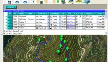
Importation/Exportation: Import/export trails to gpx file. Unlimited number of trails, and TrackPoints. Export to gpx, Excel, PDF, XPS and KML/KMZ. Data table: Very flexible data table that allows sorting by columns, with inheritance of data, attributes, etc. Presentation on map: View on map in accordance with the active trail, which comes from providers of maps, as in 'Satellite' mode (photos, orthophotos, etc), as 'Map' mode, (Topographic map, street maps, etc). Digital Terrain Model, DTM: I have downloaded all the files, patches, with elevations of a point every 90 metres from around the world and 30 meters for United States, (DEM, digital elevation model), taken by the 'Shuttle Radar Topography Mission', SRTM. I've put all these files on a dedicated server that can access all from anywhere. And with these files is created the DTM and contouring map of that we are seeing on the map in that moment. Longitudinal profile: Profile with direct and reciprocal relationship with the TrackPoints and WayPoints of the active trail. Edition of trails: It's the tool more powerful has the program and, in fact, was so started the program, to be able to edit my trails. You can create, modify, join, split and delete trails graphically. And the best is that this is done graphically on the map by clicking on the trail in one way easier. Display/management of photographs: I have created an images viewer so that you can see them easily and rotate them if necessary. The photograph can be 'Drag and drop' on table, easily. AutoCAD/Bricscad/ZWCad: I have created the program, also, so that works within these three platforms. Thus, you can draw the trails, waypoints, digital model, map displayed, contouring and cloud of points, inside the CAD, with entities of CAD. Thus, you can have your trail in UTM XYZ WGS84 coordinates, with what that represents, thus you can include new maps of any active WMS service, (Warehouse Management System), and above all, with CAD tools.
OS: Win2000, Windows XP, Windows 7 x32, Windows 7 x64, Windows 8, WinServer, Windows Vista, Windows Vista x64
Requirements: Desktop application, MIcrosoft operating systems, 32&64 bits
Add Your Review or 64-bit Compatibility Report
Top Other 64-bit downloads


Flexify 2.1.64

Flexify: A versatile tool for seamless data manipulation and integration.
Open Source


Rocrail 2026-03-15 Revision
Rocrail: Open-source model railroad control software for automation and control.
Open Source

stretchly 1.20.0
Boost productivity with Stretchly, a break reminder app for healthier work.
Open Source


WinStars 3.0.304 (2025
Explore the cosmos with WinStars, your interactive astronomy software.
Freeware

Offline Map Maker 8.381
Create detailed offline maps from online sources with ease and precision.
Demo | $79.00

Members area
Top 64-bit Downloads
-
Fitbit Connect 2.0.2.7066
x64 freeware download -
MyTourbook 64-bit 19.6.1
x64 open source download -
JAWS 64-bit 14.0.5005
x64 trialware download -
Money Manager Ex
Portable x64 1.8.0
x64 freeware download -
Moneydance x64 2017.8 (1691)
x64 trialware download -
Deeproot Plant Base X64 2.2.0
x64 shareware download -
Money Manager Ex x64 1.8.0
x64 freeware download -
Parabator 2 1.0
x64 freeware download -
Parabator 2 -
"perk" booster
mod 1.0
x64 freeware download -
Parabator 2
"perkk"
booster mod 1.0
x64 freeware download
Top Downloads
-
Netron 8.9.9
open source download -
Flexify 2.1.64
open source download -
Easy-PC 25.0.3.85
demo download -
Rocrail 2026-03-15 Revision
open source download -
stretchly 1.20.0
open source download -
fsmapper 1.6.6
open source download -
WinStars 3.0.304 (2025
freeware download -
Anki 25.07.2
open source download -
Offline Map Maker 8.381
demo download -
dwgConvert 2024 A.11
demo download -
IRIS 5.59
freeware download -
TARGET 3001 34.2.0.45
demo download -
Desktop Projector 3.4.7
freeware download -
WriteMapper 4.5.0
demo download -
CyberSky 5.1.1
shareware download