GPS TrackMaker - X 64-bit Download
Popular x64 Tags
GPS TrackMaker 13.9.596
Sponsored links:
Geo Studio Technology

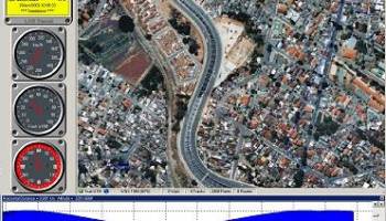
GPS TrackMaker® is the most complete free program for GPS devices!Using the Real-Time Navigation routine you can go out with a GPS conected to a portable computer, knowing exactly what's your location on the map.
Create and edit waypoints, tracklogs, routes, and insert scanned images of map. More than 160 GPS models recognized. Garmin, Magellan, Eagle and others.
You can use the resource of real-time navigation to go out with a GPS connected to a portable computer, knowing where is your location on the map
Create fast vectorial background maps
Download and upload Waypoints, Tracklogs and Routes
More than 260 waypoint icons
Calibrate map images in GIF, JPG, BMP, WMF and EMF formats
Many tools to create and edit tracklogs, waypoints and routes
General Resourses:
Complete support for Tracklogs, Routes and Waypoints edition
Database with more than 280 datums
The data can be stored in TXT , GPX, GTM and other formats
Calculates length, instantaneous and average speeds of tracklogs
Zoom in and Zoom out by keyboard or mouse wheel
Moves the whole drawn map, only with the right button of the mouse
Makes possible to change the background color, grad lines and Waypoints
Total navigation on the map image !
Makes possible to insert several scanned map images in the background
True-Grid mode
Supports files of MapInfo®, ArcView®, Google Earth® and other formats.
Real Time Navigation function
Shows and Prints more than 190 different colored icons
Print in Scale
NMEA0183 Protocol for Real Time Navigation with others GPS models
Option of Name, Style and Color for Tracklogs
Option to choose name, style and color of Tracklogs
OS: Windows XP, Windows Vista, Windows Vista x64, Windows 7, Windows 7 x64, Windows 8, Windows 8 x64, Windows 10, Windows 10 x64
Add Your Review or 64-bit Compatibility Report
Top Geography 64-bit downloads

NTv2Creator 6.14
Modeling of NTv2 files from Identical Points in two Reference Systems
Shareware | $535.00
tags: modelling, modeling, creation, create, generate, calculate, ntv2 file, ntv2, gsa, gsb, createing ntv2 file, modeling ntv2 file, geodetic, datum shift, datum, shift, ntv2creator, killetsoft

Google Earth 7.3.6.10155
Explore the world in stunning detail with interactive 3D maps and imagery.
Freeware

21st century worldwide growth of Forest 8.24
21st century worldwide growth of Forest - a natural development simulation
Freeware
tags: 21st century, worldwide, growth, Forest, Nature, Clouds, CO2, Climate, Sunshine, Weather, Greenland, Science, Simulation, System Dynamics, dynamicons, Dynamic Applications

GeoTransformer 4.6.2.0
GeoTransformer focuses on making it easier for geocachers to process GPX filles
Freeware

GPS TrackMaker 13.9.596
Combine GPS data editor & real-time navigation with Google Maps and Google Earth
Freeware
Find Distance Between Multiple World Cities Software 7.0
Find the distance between one or more cities in the world.
Shareware | $19.99

UTM Coordinate Converter 2.0.4
An application that can convert between various Geographic Coordinate Systems
Freeware


Justmapzz 5.9.6
geo browser with multi-route calculation, tracks manager (import/export, convers
Shareware | $9.40

Members area
Top 64-bit Downloads
-
Global Mapper x64 25.1
x64 demo download -
Zekr x64 1.1.0
x64 open source download -
MusicReader 1.1.339.0
x64 trialware download -
Chord Scale Generator
64-bit 1.3
x64 trialware download -
Language Reader 2.01
x64 freeware download -
Stellarium for Windows
(x64 bit) 24.2
x64 open source download -
GEDCOM Validator 64-bit 10.0.2.0
x64 freeware download -
Swordfish x64 5.4.0
x64 trialware download -
GAMA x64 1.6
x64 open source download -
Matrex x64 2.2
x64 open source download
Top Downloads
-
Quick Horse 20.1.13
trialware download -
NTv2Creator 6.14
shareware download -
TR Assistant 2.03
demo download -
BoneLab 2.3.27
demo download -
Octave 9.3.0
open source download -
subs2srs 29.3.0.0
open source download -
MartView 2.5.4
freeware download -
Paralog 8.0.2
demo download -
STL Tracker 3.0.0.20
shareware download -
Quest 5.5 B5.5.5173.27952
freeware download -
NTv2Tools 8.13
shareware download -
tapcode 0.1.1
open source download -
Epubor Kindle DRM
Removal 3.0.19 Build 583
demo download -
Aquile Reader 1.1.61.0
freeware download -
MecaNet 22.12.29
freeware download