Metes and Bounds - X 64-bit Download
Popular x64 Tags
- calculator x64 download
- tool x64 download
- freeware x64 download
- free x64 download
- software x64 download
- download x64 download
- radio x64 download
- data x64 download
- ebook x64 download
- home inventory x64 download
- planner x64 download
- windows x64 download
- free numerology software x64 download
- free numerology x64 download
- reg software x64 download
- numerology software x64 download
- numerology x64 download
- auto repair help x64 download
- passwords x64 download
- chicken coop plans x64 download
- numerology reading x64 download
- blood pressure x64 download
- automobile x64 download
- github x64 download
- 3d modeling x64 download
- viewer x64 download
- automation x64 download
- open source x64 download
- auto x64 download
- open-source x64 download
Metes and Bounds 6.4.4r3
Sponsored links:
license: Demo ($39.95)
downloads: 481
size: 47.20 MB
updated: 2026-03-25
tags: Metes and Bounds, download Metes and Bounds, Metes and Bounds free download, plot map, calculate square feet, calculate acreage, calculator, acreage, perimeter, Square Feet
Add to Basket
Sandy Knoll Software

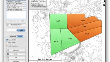
Metes and Bounds is a software that can create plot maps, perform calculations in square feets, acres, hectares, perimeter distance and more. Metes and Bounds turns data into a deed plot map. It can calculate square feet, acreage and hectares.
Enter measurements in rods, chains, meters, yards, inches, fathoms, hands, spans or furlongs. Angles can be given down to minutes and seconds. Can auto-close a plot drawing if the final plot segment is missing. Calculate area. Custom labels and backgrounds. Split single plots into multiple plots. GPS Waypoints and more.
The Drawing Wizard is an optional way to start a new drawing. It will ask you several questions about what type of drawing you plan on creating. Based on your answers to these questions, the wizard will preset some of the drawing values to help you accomplish your goals.
FEATURES:
· Perform calculations: Square Feet, Acres, Hectares, perimeter distance and more.
· Easy to use data entry form: Enter lines or curve data.
· Layers: Layers allow you to have multiple deeds on a single drawing. Layers can be free floating or locked to a common starting point.
· Metes & Bounds will calculate if the survey closes or not. Calculate closure errors.
· Auto-Completion of drawing. If you're missing the final segment of your land plotting data, let our Metes and Bounds land plotting software finish it for you. Have a bad or missing call? Enter a question mark (?) for the call and let the software find the missing call for you.
· Multiple measurement types: Data can be inputted using Feet, meters, rods, chains, varas and many other measurement types
· Easy to use measuring tool. Estimate the distance between any two points on the screen.
· Automatic labeling: Each line can be automatically labeled with the length and call. End points can be marked for easier recognition. End points can also be labeled with information like the interior and exterior angles.
Create custom labels and backgrounds. Labels can be rotated in 90 degree increments. Drawings can include a call list:
· Backgrounds can be set to scale with your plot drawing.
· Split a single plot into multiple plots. Split the plot by hand, or choose a starting point and let the Metes and Bounds software find the nearest halves automatically for you.
· Create section drawings.
· Exporting: Metes and Bounds data can be exported as a DXF file, KML File, CSV file and more.
· Printing: Printouts can include borders, call list, north arrow and title block.
· Real-world X,Y coordinates. Export real-world X,Y coordinates for integration with other mapping software such as GIS software.
· Custom X,Y points. Use custom X,Y points to mark and label unique land features on the metes and bounds drawing.
· Real-world Latitude and Longitude coordinates. Enter the latitude and longitude for a plot's POB and let the metes and bounds software calculate the latitude and longitude for each of the other end points.
· Waypoints to metes and bounds calls. Convert a set of waypoints, x/y or Latitude/Longitude based, into a list of metes and bounds calls.
· Enter Waypoints and Tracks. Add GPS waypoints and tracks to your drawings. Import GPX and KML files. Make calculations like the distance between two waypoints.
OS: Windows 11, Windows 10 32/64 bit, Windows 8 32/64 bit, Windows 7 32/64 bit
Add Your Review or 64-bit Compatibility Report
Top Other 64-bit downloads


Flexify 2.1.64

Flexify: A versatile tool for seamless data manipulation and integration.
Open Source


Rocrail 2026-03-15 Revision
Rocrail: Open-source model railroad control software for automation and control.
Open Source

stretchly 1.20.0
Boost productivity with Stretchly, a break reminder app for healthier work.
Open Source


WinStars 3.0.304 (2025
Explore the cosmos with WinStars, your interactive astronomy software.
Freeware

Offline Map Maker 8.381
Create detailed offline maps from online sources with ease and precision.
Demo | $79.00

Members area
Top 64-bit Downloads
-
Fitbit Connect 2.0.2.7066
x64 freeware download -
MyTourbook 64-bit 19.6.1
x64 open source download -
JAWS 64-bit 14.0.5005
x64 trialware download -
Money Manager Ex
Portable x64 1.8.0
x64 freeware download -
Moneydance x64 2017.8 (1691)
x64 trialware download -
Deeproot Plant Base X64 2.2.0
x64 shareware download -
Money Manager Ex x64 1.8.0
x64 freeware download -
Parabator 2 1.0
x64 freeware download -
Parabator 2 -
"perk" booster
mod 1.0
x64 freeware download -
Parabator 2
"perkk"
booster mod 1.0
x64 freeware download
Top Downloads
-
Netron 8.9.9
open source download -
Flexify 2.1.64
open source download -
Easy-PC 25.0.3.85
demo download -
Rocrail 2026-03-15 Revision
open source download -
stretchly 1.20.0
open source download -
fsmapper 1.6.6
open source download -
IRIS 5.59
freeware download -
dwgConvert 2024 A.11
demo download -
Offline Map Maker 8.381
demo download -
Anki 25.07.2
open source download -
WinStars 3.0.304 (2025
freeware download -
CyberSky 5.1.1
shareware download -
jamovi 2.6.44.0 Solid
open source download -
WriteMapper 4.5.0
demo download -
OpenComic 1.6.5
open source download