UCL Depthmap - X 64-bit Download
Popular x64 Tags
- autocad x64 download
- solidworks x64 download
- intellicad x64 download
- dxf x64 download
- dwg x64 download
- architectural x64 download
- visualization x64 download
- cad x64 download
- home x64 download
- design x64 download
- hpgl x64 download
- progecad x64 download
- animation x64 download
- fence x64 download
- cam x64 download
- dwg to pdf x64 download
- architect x64 download
- viz x64 download
- vrml x64 download
- convert x64 download
- gear x64 download
- landscape x64 download
- deck x64 download
- strength check x64 download
- batch x64 download
- garden x64 download
- yard x64 download
- gardening x64 download
- landscaping x64 download
- backyard x64 download
UCL Depthmap 0.8.0
Sponsored links:
University College London

Depthmap is a single software platform to perform a set of spatial network analyses designed to understand social processes within the built environment. It works at a variety of scales from building through small urban to whole cities or states. At each scale, the aim of the software is to produce a map of open space elements, connect them via some relationship (for example, intervisibility or overlap) and then perform graph analysis of the resulting network. The objective of the analysis is to derive variables which may have social or experiential significance.
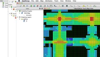
At the building or small urban scale, Depthmap can be used to assess the visual accessibility in a number of ways. It can produce point isovists, that is, polygons representing the visually accessible area from a location, along with measures of those polygons (such as perimeter, area and so on), or it can further join a dense grid of isovists into a visibility graph of intervisible points (with graphs of up to about 1000000 point locations). The visibility graph may then be analysed directly using graph measures, or used as the core of an agent-based analysis. In the agent-based analysis a number of software agents representing pedestrians are released into the environment. Each software agent is able to access the visual accessibility information for its current location from the visibility graph, and this informs its choice of next destination. The numbers of agents passing through gates can be counted, and compared to actual numbers of pedestrians passing through gates.
At the small to medium urban scale, Depthmap can be used to derive an ‘axial map’ of a layout. That is, derive a reduced straight-line network of the open space in an environment. The axial map has been the staple of space syntax research for many years, but the mathematical derivation of it is novel. The automatic derivation allows an objective map for research into city form and function. Once the map has been generated, it may be analysed using graph measures, and the measures may be transferred to gate layers in order to compare with indicators of pedestrian or social behaviour. For larger systems where the derivation algorithm becomes cumbersome, pre-drawn axial maps may be imported.
Axial maps may be broken into segment maps, or segment maps, such as road-centre line maps, may be imported directly. These may be analysed using a variety of techniques, such as according to angular separation, road distance, or segment steps. For example, number of shortest angular paths through a segment may be calculated, or the average road distance from each segment to all others may be calculated.
FEATURES:
· Visibility graph analysis
· Agent-based pedestrian modeling
· Axial, convex and segment analysis
· DXF and MapInfo MIF / MID import
· OpenStreetMap, Tiger Line and Ordnance Survey ITN layer loaders
· Text, SVG and EPS export
OS: Windows XP, Windows Vista, Windows Vista x64, Windows 7, Windows 7 x64, Windows 8, Windows 8 x64, Windows 10, Windows 10 x64, Windows 11
Add Your Review or 64-bit Compatibility Report
Top CAD 64-bit downloads

Tracfoil 4.12.07
Edit and print your ribs and airfoils templates from data
Trialware
tags: Cad, model, aircraft, plane, airfoil plotting, rib plotting, airfoil to DXF, airfoil, plot, rib

MapInfo Professional 17.0.4
Location-based decisions: Explore, model and act with confidence
Trialware | $1 995.00

nanoCAD 5.1.2524.2017
nanoCAD - easy-to-use free CAD software delivering great user experience.
Freeware

DICOMscope 3.5.1
A free DICOM viewer which can display uncompressed, monochrome DICOM images
Freeware

CrystalMaker 11.1.0
A full-featured scientific program, supporting the major database file formats
Demo | $499.00

Members area
Top 64-bit Downloads
-
Fluid Mask for Mac 3.3.14
x64 trialware download -
ICO file format x64 2.1f1
x64 open source download -
Archicad 64bit 27 B3001
x64 demo download -
WellCAD x64 5.3 B625
x64 demo download -
Portable MicroDicom x64 2024.2
x64 freeware download -
Adobe Photoshop Elements 2024.3
x64 trialware download -
TopSpice 10.26a
x64 demo download -
Potrace for Windows (x64
bit) 1.16
x64 open source download -
delaboratory x64 0.8
x64 open source download -
Photo Ninja 64-bit 1.4.0c
x64 trialware download
Top Downloads
-
CorelDRAW X5 2026 v27.0.0.121
trialware download -
Tracfoil 4.12.07
trialware download -
oCam 428.0
freeware download -
Gyazo 5.9.1
demo download -
MapInfo Professional 17.0.4
trialware download -
iWisdom 0.0.0+2107~ga0785ce1
open source download -
CodeLoader 4.19.0
freeware download -
nanoCAD 5.1.2524.2017
freeware download -
SeiSee 2.22.6
freeware download -
MarvinSketch 23.16.0
freeware download -
Scanahand 8.0.0.320
demo download -
VueScan 9.8.52
demo download -
Topaz Simplify 4.1.1
trialware download -
World Tools 2.0.6
shareware download -
Texmod 0.9b
freeware download