GeoMapApp - X 64-bit Download
Popular x64 Tags
- autocad x64 download
- solidworks x64 download
- intellicad x64 download
- dxf x64 download
- dwg x64 download
- architectural x64 download
- visualization x64 download
- cad x64 download
- home x64 download
- design x64 download
- hpgl x64 download
- progecad x64 download
- animation x64 download
- fence x64 download
- cam x64 download
- dwg to pdf x64 download
- architect x64 download
- viz x64 download
- vrml x64 download
- convert x64 download
- gear x64 download
- landscape x64 download
- deck x64 download
- strength check x64 download
- batch x64 download
- garden x64 download
- yard x64 download
- gardening x64 download
- landscaping x64 download
- backyard x64 download
GeoMapApp 3.7.1
Sponsored links:
William Haxby

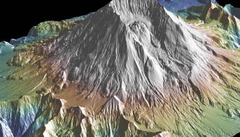
GeoMapApp is a map-based application for browsing, visualizing and analyzing a diverse suite of curated global and regional geoscience data sets. These cover geophysics, geology, geochemistry, physical oceanography, climatology, and more.
GeoMapApp provides data layering, display customization and analytical tools to support the analysis of multidisciplinary data sets. Choose from Mercator, North polar and South polar projections. Save the images for papers and presentations.
Users can import their own grids, tabular data, images, and shapefiles. For imported grids, the color palette, shaded relief, and contouring are customizable; users may also extract profiles and digitize grids. Imported table values can be edited and the map symbol, color and size are adjustable. Tabular values may be plotted on a graph and captured and saved with a lasso function.
Several custom portals provide visualization and basic analysis for data types that typically require specialist software. Examples include seismic reflection profiles and geodetic velocity vectors.
The GMRT base map provides multi-resolution global elevation data upon which other data sets can be layered.
GeoMapApp is developed and maintained as part of the Marine Geoscience Data System (MGDS) at Lamont-Doherty Earth Observatory of Columbia University.
OS: Windows 2000, Windows 2003, Windows XP, Windows Vista, Windows Vista x64, Windows 7, Windows 7 x64, Windows 8, Windows 8 x64, Windows 10, Windows 10 x64, Windows 11
Requirements: Java 8
Add Your Review or 64-bit Compatibility Report
Top CAD 64-bit downloads

Tracfoil 4.12.07
Edit and print your ribs and airfoils templates from data
Trialware
tags: Cad, model, aircraft, plane, airfoil plotting, rib plotting, airfoil to DXF, airfoil, plot, rib

nanoCAD 5.1.2524.2017
nanoCAD - easy-to-use free CAD software delivering great user experience.
Freeware


MapInfo Professional 17.0.4
Location-based decisions: Explore, model and act with confidence
Trialware | $1 995.00
DICOMscope 3.5.1
A free DICOM viewer which can display uncompressed, monochrome DICOM images
Freeware

CrystalMaker 11.1.0
A full-featured scientific program, supporting the major database file formats
Demo | $499.00

Members area
Top 64-bit Downloads
-
Fluid Mask for Mac 3.3.14
x64 trialware download -
ICO file format x64 2.1f1
x64 open source download -
Archicad 64bit 27 B3001
x64 demo download -
TopSpice 10.26a
x64 demo download -
WellCAD x64 5.3 B625
x64 demo download -
Portable MicroDicom x64 2024.2
x64 freeware download -
Adobe Photoshop Elements 2024.3
x64 trialware download -
Potrace for Windows (x64
bit) 1.16
x64 open source download -
delaboratory x64 0.8
x64 open source download -
AcroPDF 6.2
x64 shareware download
Top Downloads
-
CorelDRAW X5 2026 v27.0.0.121
trialware download -
Tracfoil 4.12.07
trialware download -
oCam 428.0
freeware download -
Gyazo 5.9.1
demo download -
nanoCAD 5.1.2524.2017
freeware download -
MarvinSketch 23.16.0
freeware download -
MapInfo Professional 17.0.4
trialware download -
iWisdom 0.0.0+2107~ga0785ce1
open source download -
CodeLoader 4.19.0
freeware download -
SeiSee 2.22.6
freeware download -
XnConvert 1.106.0
shareware download -
Scanahand 8.0.0.320
demo download -
VueScan 9.8.53
demo download -
Topaz Simplify 4.1.1
trialware download -
World Tools 2.0.6
shareware download